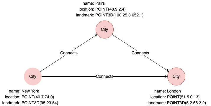
示例图集
以下示例根据该图集运行:
distance()
计算两个坐标点之间的直线距离。
| 语法 | distance(<point1>, <point2>) |
||
| 参数 | 名称 | 类型 | 描述 |
<point1> |
POINT或POINT3D |
第一个点 | |
<point2> |
POINT或POINT3D |
第二个点 | |
| 返回类型 | DOUBLE |
||
find().nodes({name == "New York"}) as p1
find().nodes({name == "London"}) as p2
return distance(p1.location, p2.location)
结果:
| distance(p1.location, p2.location) |
|---|
| 5571177.78487926 |
point()
构建一个二维地理坐标。可使用point()函数指定point类型属性值。
| 语法 | point({latitude: <lati>, longitude: <longti>}) |
||
| 参数 | 名称 | 类型 | 描述 |
<lati> |
数值 | 纬度值 | |
<longti> |
数值 | 经度值 | |
| 返回类型 | POINT |
||
return point({latitude:39.9, longitude:116.3}) as point
结果:
| point |
|---|
| POINT(39.9 116.3) |
insert().into(@City).nodes([{name: "Tokyo", location: point({latitude: 35.7, longitude: 139.7})}]) as n
return n.location
结果:
| n.location |
|---|
| POINT(35.7 139.7) |
point3d()
构建一个三维笛卡尔坐标。可使用point3d()函数指定point3d类型属性值。
| 语法 | point3d({x: <value_x>, y: <value_y>, z: <value_z>}) |
||
| 参数 | 名称 | 类型 | 描述 |
<value_x> |
数值 | x值 | |
<value_y> |
数值 | y值 | |
<value_z> |
数值 | z值 | |
| 返回类型 | POINT3D |
||
return point3d({x:10, y:15, z:5}) as point3d
结果:
| point3d |
|---|
| POINT3D(10 15 5) |
insert().into(@City).nodes([{name: "Tokyo", landmark: point3d({x:10, y:15, z:5})}]) as n
return n.landmark
结果:
| n.landmark |
|---|
| POINT3D(10 15 5) |